| People | Forum | Koforidua | Geography | Photos 1 | Photos 2 | Neighbours | Video | Squidoo |
Ghana news ô ô ô ô Ghana country ô ô ô ô Good day, it is 30. 01. 2026, Friday in 5. week. ô ô ô ô Ghana business ô ô ô ô Ghana sport ô ô ô ô
Lake Volta
| Line 1: | Line 1: | ||
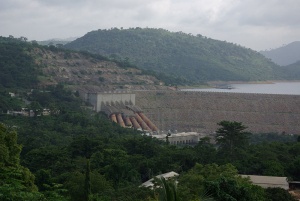
| ã | + | [[Image:HydroelectricPlantOnLakeVolta.jpg|thumb|300px|Hydroelectric Plant on the Lake Volta]] | |
| ã | | | + | |
| ã | | | + | |
'''Lake Volta''' is the largest [[reservoir (water)|reservoir]] by surface area in the world, lying in [[Ghana]] and covering almost [[1 E9 môý|8,502 kmôý (3,275 square miles)]]. Its northernmost point is at the town of Yapei, and southernmost at the [[Akosombo Dam]], 520 kilometers downstream. The dam holds back the [[White Volta River]] and the [[Black Volta River]]. These two rivers formerly converged to form the [[Volta River]]; this river now flows from the dam to the [[Atlantic Ocean]]. | '''Lake Volta''' is the largest [[reservoir (water)|reservoir]] by surface area in the world, lying in [[Ghana]] and covering almost [[1 E9 môý|8,502 kmôý (3,275 square miles)]]. Its northernmost point is at the town of Yapei, and southernmost at the [[Akosombo Dam]], 520 kilometers downstream. The dam holds back the [[White Volta River]] and the [[Black Volta River]]. These two rivers formerly converged to form the [[Volta River]]; this river now flows from the dam to the [[Atlantic Ocean]]. | ||
| Line 14: | Line 12: | ||
*[http://www.ghanaweb.com/GhanaHomePage/tourism/akosombo.php Lake Volta on ghanaweb.com] | *[http://www.ghanaweb.com/GhanaHomePage/tourism/akosombo.php Lake Volta on ghanaweb.com] | ||
| ã | |||
| ã | |||
<center> | <center> | ||
| ã | |||
<googlemap lat="6.6246" lon="-0.19635" zoom="7" width='300' height='300' > | <googlemap lat="6.6246" lon="-0.19635" zoom="7" width='300' height='300' > | ||
6.6246, -0.19635, [[Lake Volta]] | 6.6246, -0.19635, [[Lake Volta]] | ||
| Line 23: | Line 18: | ||
Lake Volta | Lake Volta | ||
</center> | </center> | ||
| ã | + | ==Source== | |
| + | http://en.wikipedia.org/wiki/Lake_Volta | ||
| + | |||
{{OEC}} | {{OEC}} | ||
[[category:geography]] | [[category:geography]] | ||
Latest revision as of 08:25, 6 May 2012
Lake Volta is the largest reservoir by surface area in the world, lying in Ghana and covering almost 8,502 kmôý (3,275 square miles). Its northernmost point is at the town of Yapei, and southernmost at the Akosombo Dam, 520 kilometers downstream. The dam holds back the White Volta River and the Black Volta River. These two rivers formerly converged to form the Volta River; this river now flows from the dam to the Atlantic Ocean.
The lake was formed in 1965 when the Akosombo Dam was built. Owing to the formation of Lake Volta, 78,000 people were relocated to new townships, along with 200,000 animals belonging to them; 120 buildings were destroyed.
The Akosombo Dam provides electricity for much of the nation. It is also important for transportation, plied by both ferries and cargo boats.
The Digya National Park lies on part of the lake's west shore.
On April 9, 2006 a passenger boat sank in the lake drowning around 120 people.
External links
<googlemap lat="6.6246" lon="-0.19635" zoom="7" width='300' height='300' > 6.6246, -0.19635, Lake Volta </googlemap> Lake Volta
Source
http://en.wikipedia.org/wiki/Lake_Volta
Main: Main Page, Advice, Nabuur, Schools in Oyoko
Geography: African countries 1, African countries 2, Akosombo Dam, Ghana, Koforidua, Lake Volta, Oyoko, Regional capitals of Ghana
Neighbours: Barb Briggs, Ernest Okrah - local representative, Frantisek Korbel, Jean-Claude Kamwenubusa, Ken Hargesheimer, Mazombo Menga Rodolphe, Pelle Aardema, Raul Alberto Caceres, Stella Akiteng, Sushmita Lahiri
Promotion: Link exchange, Photo gallery 1, Photo gallery 2, Video, YouTube channel
Education: Arithmetics training, English alphabet, English plural exceptions,
Lanthanoids, Periodic table, Useful information
Statistics: Web statistics Visits in 2008: June, July, August, September, October, November, December Visits in 2009: January, February
